Statues - Hither & Thither |
Site Search:
|
|
Marktredwitz
Lkr. Wunsiedel im Fichtelgebirge Bayern Ottostraße
|
50. Breitegrad-Denkmal50th Parallel-Monument |
Melita Todorocic & Günther Mauermann
1988 |
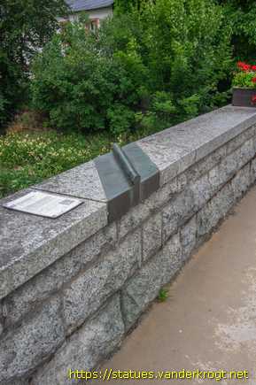
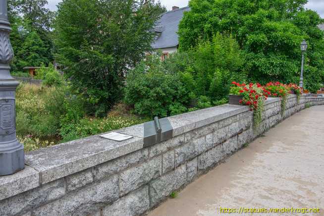
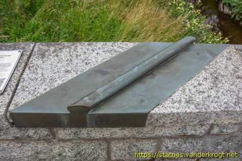
Eine Bronzewulst am Brückengeländer markiert die Stelle, an der der 50. Breitengrad die Brücke kreuzt. Oben links neben der Wulst befindet sich an der Oberkante ein Kompass mit der Jahreszahl 1988.
Links und rechts stehen die Namen Dörflas und Marktredwitz. Dorflas und Marktredwitz – seit 1949 eine Gemeinde. Marktredwitz gehörte früher zum Markgrafentum Brandenburg-Bayreuth, während Dorflas ein egerisches Reichslehen war. Das Denkmal ist somit zugleich ein Denkmal für die alte Grenze.
An der Rille sind außerdem Namen weiterer Orte auf dem 50. Breitengrad mit der Entfernung angegeben, u. a. auf der Ostseite die Insel Sachalin (Sowjetunion) 9390 km und auf der Westseite Winnipeg (Kanada) 7860 km (Dies ist die Entfernung entlang des 50. Breitengrades; die kürzeste Entfernung - entlang des Großkreises - beträgt 8000 bzw. 7040 km).
Laut Google Earth liegt die Position des Denkmals bei 49°59'56" N, und verläuft der 50. Breitengrad etwa 120 m weiter nördlich, ungefähr an der Kreuzung von Ottostraße und Leopoldstraße.
A bronze ridge on the bridge railing marks the point where the 50th parallel crosses the bridge. At the top left, next to the ridge, there is a compass bearing the year 1988. On the left and right are the names Dörflas and Marktredwitz. Dörflas and Marktredwitz have been a single municipality since 1949. Marktredwitz formerly belonged to the Margraviate of Brandenburg-Bayreuth, whilst Dörflas was an fief of Eger. The monument therefore also serves as a memorial to the old border.
Along the ridge, the names of other locations on the 50th parallel are also listed, together with their distances; these include, on the eastern side, Sakhalin Island, Soviet Union, 9,390 km, and on the western side, Winnipeg, Canada, 7,860 km (this is the distance measured along the 50th parallel; the shortest distance – along the great circle – is 8,000 and 7,040 km respectively).
According to Google Earth, the monument’s position is 49°59'56" N, and lies the 50th parallel approximately 120 metres further north, roughly at the junction of Ottostraße and Leopoldstraße.
|
DORFLÄSER BRÜCKE MIT 50. BREITEGRAD Am Ort der Dorfläser Brücke befand sich schon im Mittelalter eine alte Flussüberquerung, zunächst als Furt, später in Form von zwei Brücken über den eigentlichen Kösseinelauf und den abgezweigten Mühlbach. Hier verlief die Handelsstraße nach Süden. Bei der Flussregulierang in den 1930er Jahren wurde eine Brücke erbau, die 1988 durch einen Neubau ersetzt wurde Den Verlauf des 50. Breitengrades symbolisiert eine Bronzetafel auf der Brüstung. An die jahrhundertelang bestehende Grenze zwischen dem egerischen und markgráflichen Gebiet erinnert die Stele neben der Brücke. |
DORFLÄS BRIDGE WITH 50TH PARALLEL At the site of the Dorfläs Bridge, there had already been an old river crossing since the Middle Ages, initially as a ford, and later in the form of two bridges spanning the main course of the Kösseine and the branching Mühlbach. This is where the trade route ran towards the south. During the river regulation works in the 1930s, a bridge was built, which was replaced by a new structure in 1988 A bronze plaque on the parapet marks the course of the 50th parallel. The stele next to the bridge commemorates the border that existed for centuries betweenthe territories of Eger and the Margrave. |

Your banner here? Click for information.